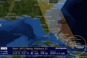
Hurricane Hanna’s current projected track takes it right up the eastern seaboard, which means it will sideswipe us here in Florida. The current speed is rather slow, like Fay, so we can expect some decent rain. The ground is still soggy from Fay, a week and a half ago. Creeks will flood, bridges will close, people will lose power. Many will worry far more than is necessary. Welcome to Florida! =]
Also, something that people tend to forget is that meteorology is anything but an exact science. We(as a race) can say with some level of certainty that a storm will head NW until it hits the US(then NE usually), but the smallest change in course amounts to a huge difference of where/when/if it hits us. So just keep that in mind, you worry-warts.
Attached is an image of the current track courtesy of StormPulse.com:
Soon(roughly 8AM Wednesday in the image) it will strengthen to a Category 2 hurricane. When it gets back into open water it will probably speed up a little, too.

